Our GBInSAR LiSAmobile system is the natural evolution of the LISA system, the result of years of research at the Joint Research Centre Protection and Security of the Citizen unit of the European Commission. The result is a system to measure and track the behavior and deformation of structures and terrain.
It uses an interferometric sensor based on the synthetic aperture radar (SAR) technique similar to the one used on satellites but implemented in a ground-based platform (GBInSAR or TInSAR). The system is completed and integrated by specific software packages developed for this purpose to acquire, process and analyze the data collected from the sensor.
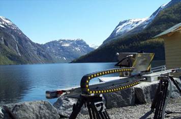
The sensor, known as GBInSAR LiSAmobile, has an high degree of operative flexibility, in terms of:
 observation frequency; observation frequency;
acquisition geometry;
polarisation;
acquisition frequency and easiness of installation even in a very short time, in order to warrant the adaptability in every situation.
In the last years the GBInSAR LiSAmobile system underwent complex experimentation activities and performances application validation thanks to more than over a hundred measurement campaigns.
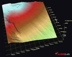
It is able to return three-dimensional and multi-temporal displacement maps giving an immediate picture of the state and the distribution of the movements activity so that a comparison between the results acquired by the GBInSAR LiSALab system and those acquired with a traditional one can be made.
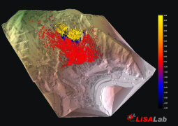
The ability of the technique is to provide areal type information over large sites and this can be considered as a viable complement to the traditional methods usually based on measuring points.
Such a feature is essential in the field of danger-zone detection, providing a powerful instrument for identifying and assigning a perimeter to the most critical areas and for programming and projecting the most suitable relief/safeguard interventions.
This application has a lot of advantages amongst which the principal ones are:
total independence of the system from reference points put on the examined object, the measured  area does not require a human presence, which would be dangerous or impossible in the case ofa landslide, and the manufact has not to be touched by means of invasive or anti-aestheticinterventions, which is important for national heritage; area does not require a human presence, which would be dangerous or impossible in the case ofa landslide, and the manufact has not to be touched by means of invasive or anti-aestheticinterventions, which is important for national heritage;
 insensitivity of the system to disturbance andinterference, which until today has been present in the
measurement area;
insensitivity of the system to disturbance andinterference, which until today has been present in the
measurement area;
ability to generate extensive displacement maps ofthe analysed objects and to operate also at a longrange, with an average operative distance of about2Km and a maximal one of about 5km withoutlimitations due to lighting or atmospherical conditions;
extreme setting up speed, between 1 and 2 hours;
the high level of system availability with continuousacquisition 24hrs per day, 7 days per week and 365 day per year;
the possibility to provide measurement in "near-realtime" with a minimal observation frequency of animage every few minutes;
the extreme precision of the measurements, usuallyin the order of 0,3-0,7mm.
The system has been tested and validated in various application fields such as:
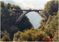 sensing and monitoring displacements in structures,buildings, bridges, dams and historical monuments;
sensing and monitoring displacements in landslides,subsidences,ground and volcanic movements;
accurate and local Digital Elevation Models production;
in the field of danger-zone detection;
in monitoring the effect of excavation activities on slopestabilities;
in monitoring areas subjected to movements or subsidencescaused by underground excavation;
to validate theorical model about the behaviour of structuresand ground;
in support of monitoring webs with traditional instruments either already installed and working orin the installation phase. The technique provides a complementary evaluation to optimise thedistribution of such sensors and contributes in locating areas with relevant displacements;
in emergency situations, when a critical event is considered imminent or just occurred, especiallyin cases in which elements of particular relevance are at risk, such as the life of rescue teams,inhabitated districts, communication ways or things that involve national heritage;
everyday the systems development produces newer and more interesting applications...
Advantages in using the GBInSAR LiSAmobile can be taken from:
Public agencies or bodies such as Civil Protection Department, national technical services,Environmental Protection Agencies,geological surveys, fire departments, dam monitoring agencies;
National, regional, provincial or municipal administrations;
Home Affair Minister, through the Prefecture and Public Works Minister, the cultural heritage andenvironmental Ministers;
the sovranational institutions and the development banks such as United Nations, European Unionand Regional Development Banks;
the big infrastructures managing companies such as highways, railways, underground andelectricity producers;
the owner or manager of dams;
the assurance and reassurance companies;
the real estate or heritage owner;
the engineering and construction companies;
the mining or excavation industries.
|